
The Importance of Robust Capture Design and QA for Bridge Reality Capture
High-resolution cameras, LiDAR and modern photogrammetry software have made it increasingly practical to create detailed digital records of even the largest and most complex bridge structures.
But the quality of the final reality model is determined long before reconstruction begins.
For large and complex bridges, the main challenge is not simply collecting enough data. It is designing an image network that provides the required coverage, resolution and viewing geometry and then verifying that the planned capture is actually capable of observing the structure adequately.
As structures become larger, access becomes more constrained and reconstruction times increase, this becomes increasingly important.
A workflow based on iterations - capture, process, identify gaps and return to the field - may be manageable on a small structure. On a large bridge, it can quickly become inefficient.
More Images Do Not Necessarily Mean Better Capture
It is easy to assume that collecting more imagery will automatically produce a better model. That is not necessarily the case.
Photogrammetry depends on relationships between images. Structural surfaces need to be observed from enough useful positions and angles for the reconstruction software to establish reliable correspondence.
Bridge structures make this particularly challenging because they often contain:
repetitive geometry;
closely spaced structural members;
deep girders and trusses;
complex connections;
hidden or occluded surfaces;
underside elements;
changing elevations; and
areas where access is limited.
A dataset can therefore contain thousands of images while still having weak coverage in locations that matter.
The question is not how many images were collected? The more useful question is whether the right images were collected, from the right locations, with the right viewing geometry.
Capture Planning Should Begin With the Engineering Question
Capture planning should begin with the engineering question being asked.
Different objectives require different evidence. Documenting coating condition across a large structural area may require one capture strategy. Recording a gusset plate, bearing or connection may require another. Monitoring a known defect through multiple inspection cycles may require much tighter control over resolution, orientation and repeatability.
The engineering objective should therefore influence:
sensor selection;
required resolution;
standoff distance;
image overlap;
viewing angles;
survey control;
capture zones;
flight paths; and
QA requirements.
The sensor is one part of the solution. It should not define the problem.
Using Structure Geometry to Design the Capture
LiDAR can provide a useful geometric basis for capture planning. Once the structure geometry is available, it becomes easier to understand:
where important surfaces are located;
where occlusions are likely;
how far cameras should be positioned from the structure;
which viewing angles are required;
where programmed flight paths may be useful; and
where supplemental capture may be necessary.
This allows acquisition to be designed around the actual geometry of the bridge rather than relying entirely on field intuition.
For relatively simple surfaces, conventional flight patterns may be sufficient. Around complex steel connections, however, the aircraft may need to deliberately change position, elevation and viewing direction to build a sufficiently strong image network around the component.
The objective is not simply to photograph the structure. The objective is to create enough useful geometric relationships between images to support reliable reconstruction.
QA Should Begin Before Full Reconstruction
Good capture design also requires a way to verify that the planned image network is providing the intended coverage.
Waiting for a complete reality model before identifying weaknesses can be too late, particularly on a large and complex structure.
For the Blue Water Bridge, a scripted QA approach was used to compare planned camera positions and fields of view against the structure geometry, allowing coverage to be evaluated before production capture field work begins.
The example below shows this type of analysis applied to one bridge capture zone.
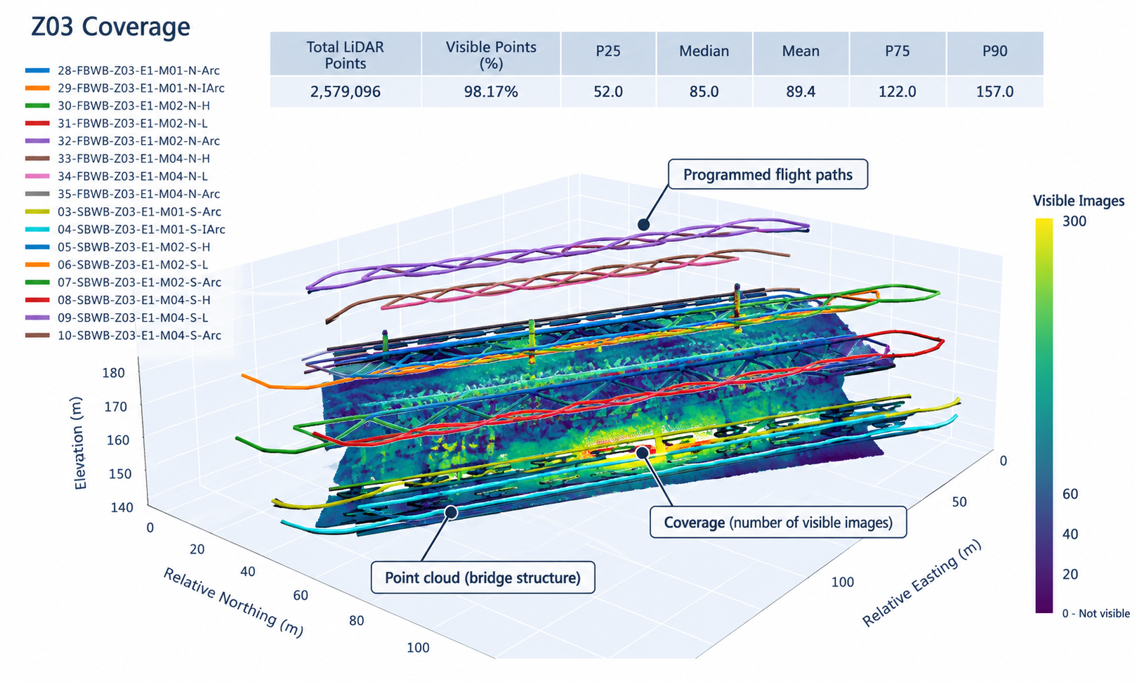
Example of coverage verification using programmed flight paths and camera field of view projected against a LiDAR point cloud.
In simple terms, the process addresses the question: How well can the planned imagery actually see the structure?
The LiDAR point cloud provides the geometric representation of the bridge, while the planned camera positions and orientations define the image network. Each camera’s field of view can then be projected against the point cloud to estimate how frequently different parts of the structure are observed.
In the example shown, approximately 2.58 million LiDAR points were evaluated, with 98.17% identified as visible from at least one planned image. The analysis also shows how many images observe individual areas of the structure, rather than relying on a single overall coverage percentage.
That distinction matters.
A surface visible in only one image is not necessarily sufficiently documented for reliable photogrammetric reconstruction. Stronger portions of the image network may be observed from dozens of viewpoints, while weaker areas may have significantly less coverage.
By identifying those differences before reconstruction, the capture design can be refined to improve image-network strength, address potential coverage gaps, and reduce the likelihood of discovering deficiencies only after processing begins.
The objective is not simply to maximize the number of images. It is to create a well-designed image network with sufficient coverage and viewing geometry to support a reliable reality model.
From Visual Judgment to Quantitative Capture QA
Field experience remains important. An experienced pilot, geomatics specialist or engineer can often identify obvious gaps, occlusions and difficult areas during acquisition. However, large bridge datasets can quickly become too complex to assess reliably through visual review alone.
A single capture zone may contain thousands of images, with structural surfaces partially obscured by girders, bracing and other components. Weaknesses in coverage or viewing geometry may not be apparent from the flight plan and may otherwise remain undetected until photogrammetric processing begins.
Quantitative QA provides an additional means of evaluating whether the planned image network has sufficient coverage, redundancy and viewing geometry to support reliable reconstruction.
Applying these checks during capture design can identify weakly observed areas and potential gaps before mobilization, allowing flight paths, camera orientations or supplemental capture requirements to be refined in advance.
The same principles can also support field verification during acquisition, providing measurable criteria for assessing capture completeness before leaving the site.
This reduces reliance on subjective review alone and helps establish a more consistent and defensible approach to reality-data acquisition.
Why Capture Deficiencies Become More Costly on Large Structures
On a small structure, incomplete reconstruction can sometimes be corrected relatively easily. The team can identify a missing area, return to the site, collect additional imagery and rerun the model. The economics change significantly on a major bridge.
A production deployment may involve:
tens or hundreds of thousands of images;
numerous capture zones;
extensive flight programming;
survey crews and control;
traffic or operational coordination;
access restrictions;
significant mobilization effort; and
long reconstruction times.
A deficiency discovered during processing may have originated several days earlier during acquisition. By the time it is identified, the field team may already have moved to another area or demobilized completely. The structure may also require permits, traffic control, specialized access or other coordination before supplemental capture can occur. Discovering capture deficiencies only after reconstruction can be costly, as gaps may require additional processing, remobilization, supplemental field capture, or acceptance of incomplete areas in the final model.
Moving Uncertainty Upstream
Reality capture will always involve some iteration. Field conditions change. Structures reveal unexpected challenges. Processing may expose issues that were difficult to anticipate. The objective is not to eliminate iteration entirely. The objective is to shift more of the uncertainty into the planning and verification stages, reducing dependence on reconstruction as the primary means of identifying capture deficiencies.
That does not guarantee a perfect dataset. It does, however, reduce dependence on full reconstruction as the primary QA mechanism. For infrastructure projects, this can significantly reduce the risk of costly rework.
Different Parts of the Bridge May Require Different Capture Methods
A bridge is not a single homogeneous object. The deck, girders, bearings, gusset plates, piers, abutments, underside, drainage components and surrounding site may each present different visibility and access challenges.
No single sensor or capture method will be ideal everywhere. Depending on the objective, the appropriate solution may involve a combination of:
aerial imagery;
LiDAR;
handheld photography;
terrestrial scanning;
infrared imaging; or
other sensing technologies.
The underside of a bridge, for example, can present fundamentally different challenges than exposed exterior surfaces. Complex steel connections may require carefully designed multi-angle imagery. Other conditions may not be visible using conventional RGB photography at all. Sensor selection should therefore follow the information requirement rather than being predetermined.
Capture Design Also Supports Repeatability
Capture planning becomes even more important when the objective extends beyond creating a one-time model. If the same bridge will be documented during future inspections, maintenance activities or rehabilitation work, the original capture methodology becomes part of the long-term record.
Consistency in:
capture zones;
coordinate systems;
survey control;
resolution;
viewing geometry; and
QA requirements
can make future comparisons more meaningful.
A well-designed baseline therefore does more than support today's reconstruction. It establishes the reference condition for future capture cycles. This is where reality capture begins to move beyond visualization and toward longitudinal condition documentation.
The Quality of the Model Is an Output of the Capture Strategy
Modern photogrammetry and reality-modelling software is extremely capable. But processing cannot reliably recover information that was never captured. A model can be visually impressive while still containing incomplete surfaces, weak geometry, or insufficient detail in areas that matter to an engineer.
For engineering applications, the value of a reality model depends less on how it looks and more on whether the underlying capture provides sufficient coverage, resolution, and geometric reliability for the intended use.
Creating a high-quality bridge digital twin therefore requires capture requirements to be established before the first image is collected and verified again during field acquisition. Robust capture design and QA moves reality capture beyond simple data collection and toward a more controlled, repeatable and defensible engineering measurement process.
The structures that matter most — the ones that cost the most to rehabilitate and the most to get wrong — are exactly the ones where a workflow built around iteration and field intuition is least adequate. Capture design is where that gap gets closed, or doesn’t.
